My watershed?
Descriptions Cities and Conservancies
Loma Alta Creek
Buena Vista Creek
Agua Hedionda Creek
San Marcos Creek
Canyon de las Encinas
Cottonwood Creek
Escondido Creek
Which is my watershed?
Because of their size and natural orientation, some watersheds e.g. the Escondido Creek span across several political boundaries including unincorporated portions of San Diego County. Also, some creeks have different names depending on the fork of the creek i.e. some long time residents use fork names to refer to the entire creek.
Thus, you may live in different watershed or creek than you would otherwise might think.
Use this maps on the right determine in which watershed you live so that you can target your volunteer activities or your contributions.
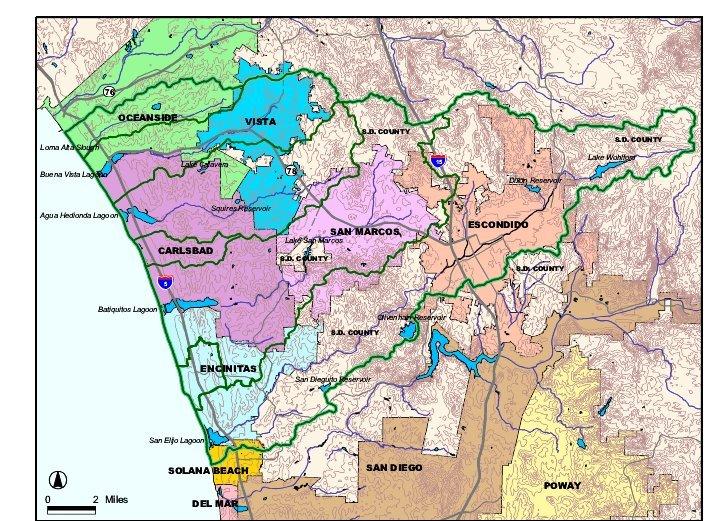
You can also view higher resolution versions of the same map of the CHU
found in the box on the right of this page to determine which is your
watershed.
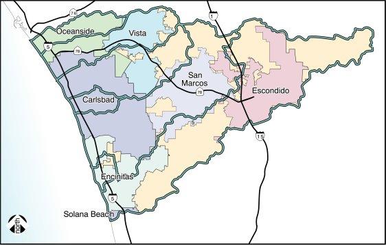
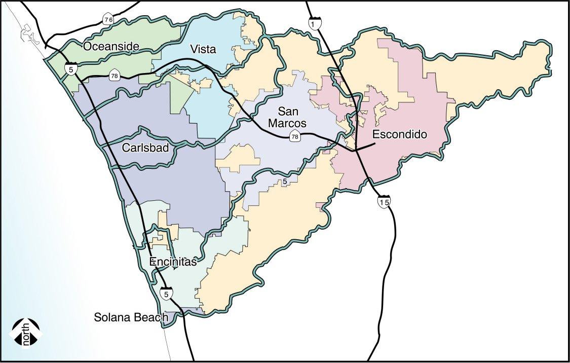
Watershed Descriptions, Cities, and Conservancies
The watersheds within the Carlsbad Hydrologic Unit vary in size, distance and resources, some cross several municipalities, and some municipalities are part of several watersheds.
Loma Alta
Description: The Loma Alta Creek watershed is approximately 6,277 acres in area,  comprising
4% of the Carlsbad Hydrologic Unit. The watershed extends inland about 7.29
miles and the high elevation within the drainage area is 460 feet above mean sea
level.
comprising
4% of the Carlsbad Hydrologic Unit. The watershed extends inland about 7.29
miles and the high elevation within the drainage area is 460 feet above mean sea
level.
Cities: The Loma Alta Creek watershed is almost completely contained within the City of Oceanside. The City of Vista enters the watershed at its extreme eastern end and a very small enclave of San Diego County is also present in this area.
Conservancy:Loma Alta Technical Advisory Committee
Buena Vista Creek
Description: The Buena Vista Creek Watershed extends approximately 10.60 miles  inland from the coast and totals 14,437 acres in area, comprising 11% of the Carlsbad Hydrologic Unit. Buena Vista Creek originates on the western slopes of the San Marcos Mountains and discharges into the Pacific Ocean via Buena Vista Lagoon.
Cities: The City of Vista occupies the majority of the upper basin and the western lower basin, while the San Marcos Mountains and portions of the southeastern corner of the upper basin are under the jurisdiction of San Diego County. In the lower basin of the watershed, the majority of the area north of State Route 78 is under the jurisdiction of the City of Oceanside; the southeastern corner of the city also extends south of State Route 78. In addition, the area south of the SR 78 is administered by the City of Carlsbad.
The California Department of Fish and Game currently manages most of Buena Vista Lagoon as a State Ecological Reserve.
Conservancy:: Buena Vista Lagoon Foundation, Friends of Buena Vista Creek
Agua Hedionda Creek
Description: Agua Hedionda Watershed dominated by Agua Hedionda Creek, extends  approximately 10.62 miles inland from the coast and is about 18,837 acres in area, comprising 14% of the Carlsbad Hydrologic Unit. Agua Hedionda Creek originates on the southwestern slopes of the San Marcos Mountains in west central San Diego County and discharges into the Pacific Ocean via Agua Hedionda Lagoon. The highest elevation within the watershed is 1,500 feet above mean sea level, located in the San Marcos Mountains. There are two reservoirs within the watershed, Lake Calavera and Squires Reservoir. Squires is used as a drinking water supply for the City of Carlsbad.
Direct ownership of much of the Lagoon is held by the Encinas Powerplant through the Cabrillo Power Company. In November 2000, the United States Fish and Wildlife Service, under the Endangered Species Act of 1973, as amended, designated Agua Hedionda Lagoon as critical habitat for the Tidewater Goby (Eucyclogobius newberryi), a federally listed endangered species.
Cities: Four municipalities and the County of San Diego have jurisdiction over the Agua Hedionda watershed as shown in Figure 4.0-2 within the Carlsbad Hydrologic Unit Overview section. Most of the lower basin is within of the City of Carlsbad, with a portion of the City of Oceanside entering the basin from the north in its midsection. The City of Vista occupies most of the middle portion of the watershed and an enclave of unincorporated County lands is also present in the northern portion of this area. West of the SR 78 corridor the majority of the lands are under the jurisdiction of the County of San Diego, and the City of San Marcos enters the watershed along its southeastern boundary.
Conservancies: Agua Hedionda Lagoon Foundation, Friends of Agua Hedionda Creek and Lagoon, Preserve Calavera
Canyon de las Encinas
Description: The Canyon de las Encinas watershed is 3,434 acres in size. The  watershed extends inland from the coast 2.37 miles and the high elevation within the drainage is approximately 430 feet above mean sea level. The watershed begins as a small drainage behind an industrial area where it is immediately channelized. The creek continues down through industrial and office parks associated with Palomar Airport until it reaches the lower valley area. It then makes its way to the Pacific Ocean after crossing Interstate 5 and Pacific Highway.
Cities: The entire watershed is contained within the City of Carlsbad.
Conservancy:
San Marcos Creek
Description: The San Marcos Creek watershed, dominated by San Marcos Creek,  extends approximately 14.11 miles inland from the coast and is about 36,050 acres in area, comprising 27% of the Carlsbad Hydrologic Unit. San Marcos Creek originates on the western slopes of the Merriam Mountains), in west central San Diego County and discharges into the Pacific Ocean via Batiquitos Lagoon. Encinitas Creek originates in the hills southwest of Questhaven Road and parallels El Camino Real before its confluence with San Marcos Creek at the southeastern corner of Batiquitos Lagoon. The high elevation within the watershed is 1,540 feet above mean sea level. Lake San Marcos is the largest impoundment within the watershed. There are also a number of small farm ponds on various tributaries in the lower basin.
Cities: Six municipalities have jurisdiction within the watershed. Additionally, unincorporated lands of San Diego County are present in all three basins. Much of the upper basin is within the unincorporated County of San Diego, with small areas administered by the City of San Marcos and the City of Escondido. The City of San Marcos (with small areas of unincorporated County lands) occupies most of the middle basin. The City of Carlsbad is the largest jurisdiction within the lower basin. However, the City of San Marcos, with an enclave of unincorporated County land, occupies the eastern edge of the lower basin. A very small portion of the City of Vista enters the lower basin of the watershed along its northern boundary. Towards the coast in the southwestern portion of the watershed, areas of land are administered by the City of Encinitas. An enclave of unincorporated County land is also present in this southwestern corner of the watershed.
The California Department of Fish and Game (CDFG) owns Batiquitos Lagoon and administers it as an Ecological Reserve.
Conservancy:: Batiquitos Lagoon Foundation
Cottonwood Creek
Description: Cottonwood Creek watershed comprises the smallest watershed within the Carlsbad  Hydrologic Unit. Within the RWQCB's San Diego Basin Plan, it is actually considered part of the San Marcos Creek watershed. Due to the fact that it discharges through a storm drain onto a public beach, along with its highly urbanized characteristics, it has been separated out within this watershed management plan.
The watershed, dominated by Cottonwood Creek, extends inland approximately 1.78 miles and is 2,175 acres in area, comprising only 2% of the Carlsbad Hydrologic Unit. Cottonwood Creek drains the western slopes of the ridge running parallel to and west of El Camino Real and the Encinitas Creek drainage. Cottonwood Creek discharges into the Pacific Ocean via a storm drain at Moonlight State Beach. The high elevation within the watershed is 400 feet above mean sea level.
Hydrologic Unit. Within the RWQCB's San Diego Basin Plan, it is actually considered part of the San Marcos Creek watershed. Due to the fact that it discharges through a storm drain onto a public beach, along with its highly urbanized characteristics, it has been separated out within this watershed management plan.
The watershed, dominated by Cottonwood Creek, extends inland approximately 1.78 miles and is 2,175 acres in area, comprising only 2% of the Carlsbad Hydrologic Unit. Cottonwood Creek drains the western slopes of the ridge running parallel to and west of El Camino Real and the Encinitas Creek drainage. Cottonwood Creek discharges into the Pacific Ocean via a storm drain at Moonlight State Beach. The high elevation within the watershed is 400 feet above mean sea level.
Cities: The entire watershed is located within the City of Encinitas.
Conservancy: Cottonwood Creek Conservancy
Escondido Creek
Description:
The Escondido Creek watershed is the largest and most complex system within the  Carlsbad Hydrologic Unit.
The watershed extends approximately 24.61 miles inland from the coast and totals 54,112 acres in area, comprising 40% of the Carlsbad Hydrologic Unit.> Escondido Creek originates in Bear Valley in north central San Diego County and discharges into the Pacific Ocean via San Elijo Lagoon. Elevations within the watershed range from sea level to 2,420 feet on the ridges above Bear Valley.
There are three main reservoirs within the watershed: Lake Wohlford, Dixon Lake, and San Dieguito Reservoir. Another major impoundment, Olivenhain Reservoir, is currently under construction.
Carlsbad Hydrologic Unit.
The watershed extends approximately 24.61 miles inland from the coast and totals 54,112 acres in area, comprising 40% of the Carlsbad Hydrologic Unit.> Escondido Creek originates in Bear Valley in north central San Diego County and discharges into the Pacific Ocean via San Elijo Lagoon. Elevations within the watershed range from sea level to 2,420 feet on the ridges above Bear Valley.
There are three main reservoirs within the watershed: Lake Wohlford, Dixon Lake, and San Dieguito Reservoir. Another major impoundment, Olivenhain Reservoir, is currently under construction.
Cities: The majority of the Escondido Creek watershed lies within the unincorporated
lands of San Diego County. Five municipalities also share jurisdiction over the
watershed, the City of Escondido being the largest municipality within the
watershed. The City of Encinitas occupies the western edge of the watershed
extending inland, north of Escondido Creek, to Rancho Santa Fe Drive; a small
portion of the City of Carlsbad also enters the watershed in this area. Just
south of San Elijo Lagoon, the northern edge of the City of Solana Beach enters
the watershed and the southern border of the City of San Marcos enters the
watershed along the north eastern edge of the lower basin. The California Department of Fish and Game owns the middle basin and portions of the western basin of San Elijo Lagoon, and manages this area as an Ecological Reserve.
Conservancies: San Elijo Lagoon Conservancy and
The Escondido Creek Conservancy
