![]()
Watershed Management Plan | FAQ's About the WMP | Executive Summary | Technical Reports and Appendices | | Meeting Agendas and Presentation | Small Changes Brochure

Located in Northern San Diego County, the Agua Hedionda Watershed provides enhanced environmental quality of life for 65,000 residents within the Cites of Carlsbad, Oceanside, Vista, San Marcos and unincorporated areas of San Diego county. 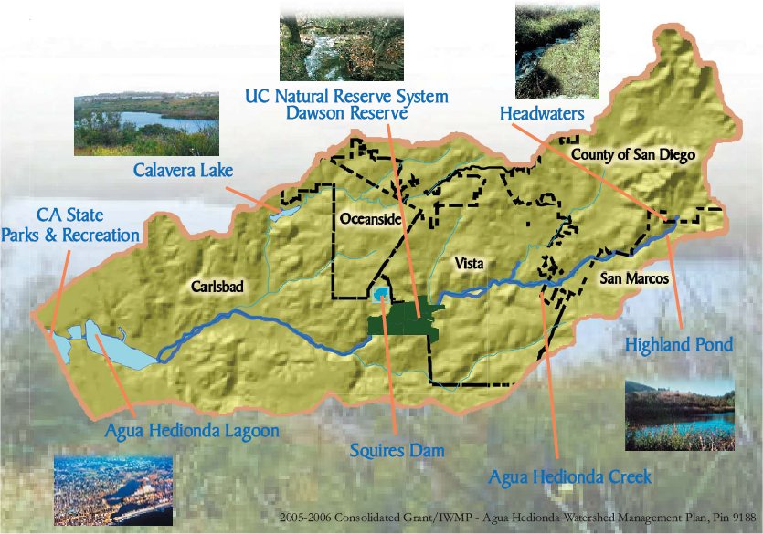
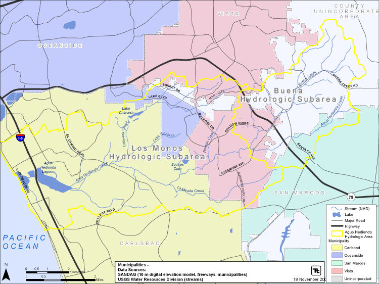
Winding it's way from the southwestern side of the San Marcos Mountains, Agua Hedionda Creek meets the Pacific Ocean approximately 10.6 miles later. Beginning on the southwestern side of the San Marcos Mountains, the Watershed winds its way to the coast, discharging into the Pacific Ocean via the Agua Hedionda Lagoon. Agua Hedionda Lagoon supports both recreational and commercial uses. It is tidally influenced with large wetlands supporting several endangered species. Agua Hedionda Creek, the major arterial for the Watershed, is feed by several tributary creeks, and Lake Calavera. Including the major tributaries there are over 70 miles of creeks or earthen channels in the watershed. Additionally residing within the Watershed is Squires Reservoir (Maerkle Reservior), a storage facility for municipal drinking water for the City of Carlsbad.
Land Use
Encompassing 18,837 acres or about 30 square-miles, the watershed includes a rapidly changing mixture of residential, commercial, agricultural, and some open space.
Historical (1986), current (2007), and planned land use (2030) information has been obtained and compiled from SANDAG. In 1986 the watershed was dominated by open space (37 percent), agriculture (19 percent) and single family residential (19 percent) areas. By 2007 single family residential acreage increased to a quarter of the watershed area, while agricultural and open spaces decreased. Residential developments spread into the central and upper watershed, bringing anthropogenic influence into closer contact with streams and displacing agriculture and open spaces. In fact, agricultural lands decreased 55% since 1986 levels. Most of the transitional areas were developed into residential and industrial spaces. Industrial and transportation lands sharply increased, especially along the southern watershed boundary.
The 2030 Regional Growth Forecast for the San Diego Region was derived from local, city, and county General & Community Planning documents (SANDAG, 2005). According to this forecast, the watershed is intended to become primarily single family residential (33 percent), industrial and transportation (23 percent), and open space (18 percent). Nearly all current agricultural land is planned for development, while open space will be reduced 39 percent from 2007 levels. Although the land use plans have provided for open space buffers along much of the streams in the lower portion of the watershed, the vast majority of the upper watershed shows development adjacent to stream corridors.
| Buildings and pavement generate more than 5 times more runoff than natural undisturbed land. Increased development generates more human activity resulting in more pollutants such as oil, pet waste, and heavy metals going into in creeks and water bodies. See Protecting Water Quality. |
Water Quality
The San Diego Regional Water Quality Control Board (SDRWQCB) has determined that the Aqua Hedionda Lagoon, Agua Hedionda Creek, and Buena Creek do not meet certain water quality objectives as shown in the table below (SDRWQCB, 2007). The SDRWQCB is in the process of developing Total Maximum Daily Loads (TMDLs) for Agua Hedionda Creek and Agua Hedionda Lagoon. The SDRWQCB is also requiring local jurisdictions to control pollutants from entering water bodies through their storm drains, referred to as municipal separate storm sewer systems (MS4), through NPDES permit requirements.
San Diego Regional Board 2006 Clean Water Act Section 303d List of Water Quality Limited Segments for the Agua Hedionda Watershed
| Waterbody Type |
Name |
Pollutant/Stressor |
|---|---|---|
Rivers/Stream |
Agua Hedionda Creek |
Manganese |
Selenium |
||
Sulfates |
||
Total Dissolved Solids |
||
Rivers/Stream |
Buena Creek |
DDT |
Nitrate and Nitrite |
||
Phosphate |
||
Estuarine |
Agua Hedionda Lagoon |
Indicator bacteria |
Sedimentation/Siltation |
A review of the existing water quality data suggests that sediment (TSS and turbidity) and bacteria (coliforms and enteroccocus) are the greatest threats to watershed function in the Agua Hedionda Watershed. Concentrations of these constituents exceed water quality objectives the majority of the time. Furthermore, significant upward trends in TSS, turbidity, and fecal coliform at the wet weather monitoring station suggest the problem is getting worse (Weston, 2007a). Turbidity was higher in the receiving water samples, an expected pattern based on the storm-driven nature of this parameter. Impairment from bacteria is, however, both a dry and wet weather problem in the watershed.
While the lack of wet weather sites inhibits the evaluation of spatial patterns, samples collected as part of the dry weather monitoring (storm drains and instream) show particularly high bacteria levels in La Mirada Creek, which drains commercial development, as well as Calavera Creek upstream of Lake Calavera. High salinity (a parameter closely related to TDS) is also found along Calavera Creek in areas draining residential development, suggesting an anthropogenic source though groundwater is likely the chief contributor to TDS levels throughout the watershed.
While nitrogen does not appear to be a significant threat in most of the watershed, the impairment of Buena Creek combined with the significant upward trend of nitrate (Weston, 2007a) suggest that it could become a problem in the future in the watershed. Phosphorus levels in the watershed are a concern: concentrations exceed the Basin Plan WQO and Buena Creek is impaired for phosphate.
There is some evidence to suggest that pesticides are a threat in the watershed; however, toxicity tests have not borne out a persistent impact on the biological community. In addition, Weston (2007a) observed that the number of pesticide exceedances have decreased since 2002. There is also little indication that metals present a significant problem for aquatic life in the watershed based on an evaluation of metals toxicity.
Given the lack of evidence for widespread and severe toxicity in the watershed, the poor biological community as seen in biotic integrity indices can likely be attributed to habitat degradation from scour during storms and sediment transport from both upland and instream sources.
Habitat Protection
Portions of Agua Hedionda Creek, particularly in the lower reaches, are protected open space areas. The City of Vista has preserved some wider riparian corridors along the creek; however, the creek is experiencing bank erosion, down-cutting, sedimentation and loss of quality habitat due to the cumulative effect of development throughout the watershed.
 |
 |
 |
| California Gnat Catcher | Brown Pelican | Least Bell's Vireo |
The watershed supports protected or endangered species, such as the Brown Pelican (Pelecanus occidentalis californicus), the California gnatcatcher (Polioptila californica californica), least Bell's vireo (Vireo bellii pusillus), yellow-breasted chat (Icteria virens), and loggerhead shrike (Lanius ludovicianus), migratory willow flycatcher (Empidonax traillii), and the light-footed clapper rail (Rallus longirostris levipes). Habitats within the watershed include Coastal Sage Scrub, Southern Maritime Chaparral, California Sage - Chaparral Scrub, Southern Cottonwood-Willow Riparian Forest, Southern Willow Scrub, Coast Live Oak Woodland, Coastal and Valley Freshwater Marsh, and grasslands.
Watershed Management Plan | FAQ's About the WMP | Executive Summary | Technical Reports and Appendices | | Meeting Agendas and Presentation | Small Changes Brochure
- About CWN
- | CHU
- | Projects
- | News/Events
- | Resources
- | Contact Us
- | Take Action
Page last updated: February 06, 2006
Copyright © 2004 Carlsbad Watershed Network. All Rights Reserved. xhtml | css